“Rockin’-‘n’-rollin’ in Hecate Strait . . .
. . . to Haida Gwaii we go! The chart shows the way ‘cross the water today through the white … Continue reading “Rockin’-‘n’-rollin’ in Hecate Strait . . .
. . . to Haida Gwaii we go! The chart shows the way ‘cross the water today through the white … Continue reading “Rockin’-‘n’-rollin’ in Hecate Strait . . .
Today (Friday, June 3) brought ashen skies above, similarly gloomy water below, and gray veils of rain to Bent Harbour. … Continue reading Ready to set sail for Haida Gwaii
It certainly WAS along the shores and around the rock clusters by which we motored today (Thursday, June 2) from … Continue reading Surf’s up!
After getting enough water under the keel to make it out of Boat Cove on Cecilia Island at about 1230, … Continue reading Bent Harbour Position Report
It’s been lovely to have a few sunny days in a row while docked in the marina and boating resource … Continue reading A sunshiny chore day, and a few more animals
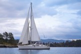
Braesail filled up all her tanks, charged her batteries, readied her sails, and in scattered clouds, pointed her bow into … Continue reading Braesail has fallen off the digital edge of the world
. . . and no fish eggs in Fish Egg Inlet that we could discover. We arrived in this very … Continue reading No oysters in Oyster Bay . . .
We are still getting used to this technology—and its limitations. We’ve anchored in Oyster Inlet at the end of Fish … Continue reading Via Iridium (and a moment of reformatting)
Safely rounding Cape Caution! A black bear! White-sand beaches! Sunshine! Peace and quiet in Fury Cove! I could have chosen … Continue reading SAILING!!
On Thursday, September 15, the GPS receiver on Braesail’s AIS system quit working. We can see other boats just fine, … Continue reading Finding (captain?) Nemo? (UPDATED September 18)
