It certainly WAS along the shores and around the rock clusters by which we motored today (Thursday, June 2) from beautifully isolated Boat Cove (at the end of shallow Boat Inlet) to Bent Harbour on Aristazabal Island off the northern B.C. coast. As the rolling four-foot ocean swells heaved Braesail up and down and to and fro, we were treated to spectacular views of surf exploding on rocks, visible and invisible, and on rugged island shores. The enthusiastic wave bursts reminded me of vivacious cheerleaders leaping up and tossing their glittering, frothy-white spray-pompoms skyward amid flashes of pale aqua green.
The sun fought off the rain showers for a short time in the morning as we did a few cleaning and maintenance tasks around the boat while waiting for the tide to rise enough to allow us a safe exit through a narrow channel that would be just over 10 ft. deep at noon (Braesail’s keel reaches nearly 7 feet down into the water). The loud, startling cry of an unseen bird echoed from the shore as we (VERY slowly and carefully!) left Boat Inlet and headed for spacious AND well sheltered Bent Harbour 36 miles away to the northwest. Prior to our departure, Walt caught a glimpse of a bear on the shore, and I suddenly thought of the old children’s song, “The Bear Went Over the Mountain”–do you know it? “The bear went over the mountain, to see what he could see. And all that he could see, all that he could see, was the other side of the mountain; the other side of the mountain was all that he could see” (sung to the tune of “For He’s a Jolly Good Fellow”). So I changed it to: “The bear went down to the seashore, to see what he could see. And all that he could see, all that he could see, was the sea beyond the seashore; the sea beyond the seashore was all that he could see.” Of course, the tune followed me all the way across the sea to our anchorage!
From Braesail’s deck we can see and hear the surf breaking on the rocks a short way outside Bent Harbour, but inside it is perfectly still and the water’s surface is mirror smooth. We will enjoy a quiet night and day tomorrow (probably with plenty of rain) before our planned sail to Haida Gwaii (formerly called the Queen Charlotte Islands), where we’ll spend two to three weeks.
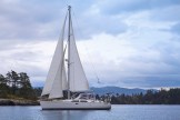
NOTE: For most of June, we’ll be unable to use the Web (I can’t see or edit the blog posts I’ve made), receive text messages, or receive email at our usual addresses. Walt has let you know that you can send a message to wrknowles@myiridium.net and our satellite phone will let us read it and reply. We CAN get all the weather and ocean-related data we need for safe traveling. I’ll continue to make blog posts, but they will have minimal formatting, and any pictures (relatively few) won’t have captions.; I will try to explain their contents in the body of the blog text. You can look back at the photos in the post, “A sunshiny chore day” about our June 1 stay at Shearwater, and (I hope!) see three pictures of the marina and its central on-shore area, and a distant view of the town of New Bella Bella, taken as we departed. The photos in this post show the entrance to Boat Inlet and some of the islets along one shore. As always, thanks for reading and “traveling” along with us!


