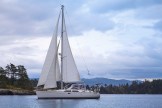
After getting enough water under the keel to make it out of Boat Cove on Cecilia Island at about 1230, we headed for Aristazabal Island (pronounced “a-ris-ta-bell” for some reason!). Because of our late start, we ran the engine a little harder than we usually do, and made 7 kts for most of the trip. Wind was all but non-existent, but seas were 2-4 feet at about 10 seconds period, mostly just aft of the beam. It gave Lorelette her first chance to experience actual ocean conditions on Braesail, and she found it quite pleasant. At 1730 we dropped hook in Bent Harbour, on the west side of south tip of Aristazabal Island (52*30.8673N, 129*03.2468W, or about 52.501*,-129.05* in decimal if you want to put it into Google Maps, though you are better off looking at it on the tracker app from PredictWind). We had a very quiet night, and we’ll be making sure everything is ready for the passage over to Haida Gwaii tomorrow. We plan on heading out into 15kt winds on a broad reach (the wind just behind us, at about 120*) and fairly calm seas.
